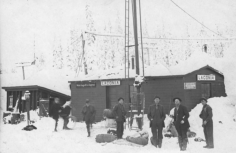
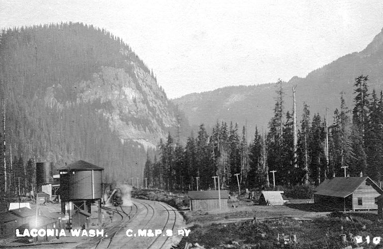
History of Laconia
Snoqualmie Pass, Washington
The Laconia railroad yard of the Chicago, Milwaukee & Puget Sound Railway (C.M.&P.S.Ry.) was located at the
summit of the Cascade High Line through Snoqualmie Pass in Washington State. The Cascade High Line ran for 9.1 miles
through the Cascade Mountains between the railroad stations of Keechelus and Rockdale, before the completion of the
2.3-mile Snoqualmie Tunnel. The Chicago, Milwaukee & Puget Sound Railway was the Pacific Coast extension of the
Chicago, Milwaukee and St. Paul Railway that was west of the Missouri River Bridge at Mobridge, South Dakota. The
name Chicago, Milwaukee & Puget Sound Railway only lasted from 1909 through 1912 and then the Pacific Coast
extension of the railroad also became known as the Chicago, Milwaukee and St. Paul Railway.
Horace Chapin Henry (1844–1928), the prominent Seattle railroad construction contractor, businessman and
philanthropist, was the principal construction contractor for clearing, grading and bridging the Chicago, Milwaukee &
Puget Sound Railway main line railroad grade all the way across eastern Washington and up through the Cascade Mountains
over Snoqualmie Pass and on down to Seattle and Tacoma. Horace C. Henry, being one of the best known railroad construction
contractors in America, was contracted for the monumental project on March 31, 1906, without competitive bidding and he
in turn subcontracted out construction work mainly to eight principal subcontractors. The main line between Laconia and
Seattle was completed on February 3, 1909, using then between Maple
Valley and Seattle acquired trackage rights on the Columbia and Puget Sound Railroad main line right-of-way. That
agreement was for between the south end of the tangent in the Maple Valley Yard and the north end of what was then
known as Island Number 1, in the tidelands at the mouth of the Duwamish River, as shown on the Seattle 1909 15-minute
USGS quadrangle map. That agreement was signed on May 21, 1906, early in the main line construction across Washington
State and it was for the term of ninety-nine years from July 1, 1907.
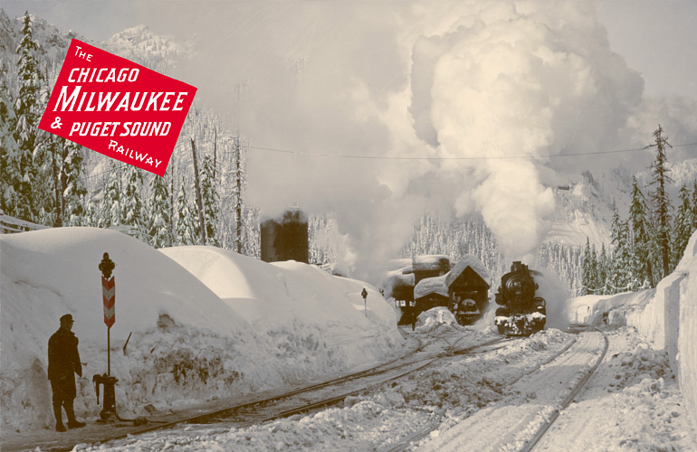
The color tinted scene shown above is of the engine house and turntable facility at the Laconia railroad yard. The
scene was photographed about 1912 by local North Bend photographer Alexander Joseph Michael Holzman
(1880–1926), who was born in Vienna, Austria, and immigrated to the United States in 1904. I scanned at high
resolution an original circa 1912 photograph and then digitally color tinted the image, to represent the natural colors of the
scene. The Chicago, Milwaukee & Puget Sound Railway logo was then added to the image for context. I think that
Alex J. M. Holzman, who died relatively young, would probably be pleased with the colored version. Shown on the main line is
Cedar Falls helper engine #8509, which was formerly numbered as #2509. When traveling eastbound a helper
engine was usually put on both passenger and freight trains at
Cedar Falls (aka Moncton) to assist in ascending the
1.74 percent grade to Rockdale. A second helper engine was usually added to freight trains at Rockdale to provide
additional assistance in ascending the 2.75 percent grade to Laconia. When traveling westbound a single helper engine
was usually put on both passenger and freight trains at Keechelus to assist in ascending the 2.2 percent grade to Laconia.
In the above scene the switch on the left is shown lined for the main line. This was the first switch between the main line and
the engine house, which had three tracks and two other switches. The water tank was just eastbound along the main line
from this switch, just beyond the left side of this view, and the small portable Laconia Depot was just eastbound from the
water tank. The shadow shown in the foreground, which angles across the railroad tracks, was probably the shadow from the
water tank. There was another switch on the main line, at the water tank, for the east crossover track that provided
access between the inner passing track and the main line and engine house lead. The west crossover track, between the
main line and the inner passing track, began on the main line immediately beyond the engine house lead. The beginning
of the west crossover track is visible, in the above scene, between the engine house lead and the locomotive shown on
the main line. When the above scene was photographed the outer passing track was buried under the wall of snow shown
on the right.


Click on map for an expanded view.
Also see oblique aerial view.
Back from oblivion Laconia reappears, as if from some faded layer of time, in this superimposed photomap of Snoqualmie
Pass, Washington. The photomap image shows an original 1913 survey map layered over a 2006 color orthophoto. The 1913
survey map shows the Cascade High Line constructed over Snoqualmie Pass in 1908 and the Laconia railroad yard facilities
constructed from about 1909 to 1911 for the Chicago, Milwaukee & Puget Sound Railway. Identified on the map are the
turntable, engine house, water tank, depot, passing tracks, hotel, bunkhouse and a couple houses. The survey stationing
is for the original location of the Sunset Highway. By Snoqualmie Pass the high line looped 172 degrees 22 minutes 12
seconds around a horseshoe curve that was 1823.7 feet in length and ran around the confluence of Commonwealth Creek with
the South Fork Snoqualmie River. The degree of curvature of the horseshoe curve was 10 degrees per 100 feet, except the
first and last 100 feet had a degree of curvature of half that amount. The horseshoe curve was designed to lengthen the
route near the summit, since a shorter route staying on the south side of the South Fork Snoqualmie River would have
been too steep. Although the railroad, during the time of the Cascade High Line, went over twenty miles through the
South Fork Snoqualmie River Valley only about one-quarter mile of that route went on the north side of the river.

This scene of the Laconia railroad station, at the summit of Snoqualmie Pass, was photographed sometime between
about 1911 and 1914. The Laconia railroad station was located below the present Summit West
ski hill. The eastbound steam train shown in this image is
approaching the location about where the present day segment of State Route 906 is now located along the front of
the Travelers' Rest. The small portable depot building is visible to the right of the water tank and set back
from the train order semaphore signal beside the third train car. The building that is partially visible behind the
steam from the locomotive is labeled on the 1913 survey map as the railroad “bunkhouse.” The long
building to the left of the bunkhouse is labeled on the 1913 survey map as the “hotel.” Also visible,
over the top of the third train car and a ways back to the left of the hotel, is the building labeled as a
“house” on the same map. The rock peak shown in the middle background of this image is Guye Peak and
the more distant snowy peak to the left of Guye Peak is Snoqualmie Mountain.
In about 1911 this small portable depot replaced an even smaller portable telegraph shack or freight shed, which
was about one-third this size and had sufficed for about a couple years or so as the first Laconia Depot building.
Shown on the depot is a sign for the Continental Telegraph Company, which was controlled by the Chicago, Milwaukee
and St. Paul Railway and had telegraph lines in Washington, Idaho, Montana, North Dakota, and South Dakota. The
tall pole with attached ladder was a train order signal mast that had a two-arm semaphore signal on top, which
conveyed signal indications for both directions of travel. The signal arm or blade that governed a train movement
was the one located to the right of the signal mast as viewed from the approaching train. This semaphore signal at
the Laconia Depot was an upper-quadrant three-aspect signal, but back then it was only used as a two-aspect train
order signal. The signal blades were about four feet long, had squared ends, and on the front side were painted red
with a white cross stripe near the outer end, and on the back side were painted white with a black cross stripe near
the outer end. Each signal blade was moved by a separate attached steel control rod, which ran up the signal mast.
When the signal blade was swung up to an upright aspect the signal indication meant “clear” to proceed
and a white lamp on the signal mast was revealed to convey that signal indication at night. When swung down to a
horizontal aspect the signal indication meant “stop” to receive train orders and a red lens attached to
the hub to which the signal blade was attached swung in front of the white lamp to convey that signal indication at
night. The train orders were issued by the station agent after inquiring with the next station ahead about the
movement of any other trains. Weather and track condition updates were also received from several track watchman
shacks located beside slide prone areas. On the other side of the main line from the depot, two passing tracks ran
for over one-half mile alongside the main line, from over one-quarter mile eastbound of the depot to over one-quarter
mile westbound of the depot. In scenes photographed in winter the outermost of the two passing tracks was often
hidden under a wall of snow, since the outer track was often used to store railcars and couldn't easily be kept
plowed open.


This color tinted scene of the Laconia engine house and turntable is a close-up view of the first scene and was
photographed in about 1912. On the left is the oil tank, which was used to fuel up the oil-fired steam locomotives.
There were two or three switches to go between the main line track and engine house, depending on which one of the
three tracks into the engine house the movement was being made on. The first switch was located on the main line
beside the water tank and was used for switching between the engine house lead and the main line, which ran beside
the depot. The kerosene switch lamp shown sticking up out of the dug out area of the snow bank was for the second
switch, which was used for switching between the middle track where the worker is shown standing and the right track,
which ran inside of the engine house all the way along the right wall. The third switch was located on the middle
track and was used for switching between the middle track and the left track, which ran along beside the oil tank and
all the way through the inside of the engine house along the left wall and out into the covered turntable facility out
back. The left track was used for turning around the helper engines and sometimes other equipment. There appears to
have been a locomotive on the left track at the time this scene was photographed, as steam is visible rising from the
left track around the bend behind the snow bank.
The locomotive shown eastbound on the main line was Cedar Falls helper engine #8509 (formerly #2509), a
superheated Class L1-as Mikado 2-8-2 locomotive, built by the Milwaukee shops in May 1909. In this scene the
locomotive was fitted for wintertime operation with an attachable pilot plow in front, which had a flanger that could
be raised and lowered as necessary for clearing snow and ice from in between the rails. Locomotive #8509 was
renumbered as #758 in June 1938. The locomotive was scrapped in December 1952 and none of its kind no longer exist.

This scene, photographed by 1912, shows an eastbound Olympian passenger train on the east end of the Cascade High
Line, approaching the Keechelus Depot, with Mt. Catherine visible in the background. Separate local freight and
passenger service over the Cascade High Line began across western and eastern Washington in June 1909, between Tacoma
and Malden. Regular freight service between Chicago and Tacoma began in July 1909 and regular passenger service across
that entire route began in August 1909. Passenger service was expanded when the Olympian and Columbian passenger trains
went into service and through express passenger train service began in May 1911. The first westbound Olympian passenger
train departed from Chicago, at 10:15 p.m., on May 28. The first eastbound Olympian passenger train departed from
Tacoma, at 7:30 a.m., on May 29. An hour and a half later that first eastbound Olympian passenger train departed from
Seattle, at 9:00 a.m., from the then brand-new Union Station that had just formally opened only nine days earlier.
Union Station was first used jointly by the Chicago, Milwaukee & Puget Sound Railway and the Oregon-Washington
Railroad & Navigation Company, which was a subsidiary of the Union Pacific Railroad. The first Olympian passenger
train to travel across Washington State was the eastbound train, first pulled by locomotive #3017, and then part
way across the state locomotive #3017 was swapped out for locomotive #3018, which took over for the next leg
of the inaugural eastbound run. Locomotives #3017 and #3018 were identical Class F4 Pacific 4-6-2 locomotives,
built by the Milwaukee shops in June 1910. The former was scrapped in May 1940 and the latter was scrapped in April
1953 and none of their kind no longer exist.

This scene was photographed in October 1913 by Asahel Curtis (1874–1941) and Walter P. Miller
(1877–1938) and shows an eastbound Olympian passenger train, with eight cars, passing the east switches of
the two passing tracks at Laconia. The early Olympian passenger trains typically consisted of, from front to back, one
combination mail and express car, one baggage car, one day coach, one tourist car, one dining car, two standard sleeping
cars and one observation car. Shown in the background on the left is Snoqualmie Mountain and on the right is Guye Peak.
The round signal number plate on the semaphore signal mast, beside the left side of the steam locomotive, shows the
number 31 over 3 that indicates that the signal was 31.3 miles beyond the division point at Cle Elum. The telegraph poles
running along the railroad can also be seen within the railroad right-of-way, which was surveyed 200 feet wide over
the summit across Section 4, T22N, R11E. The east switches of the two passing tracks at Laconia were located where
State Route 906 is now located by the Snoqualmie Pass Fire & Rescue Station (Fire District 51, Fire Station 291).


Shown above is the bottom of Table 15 and all of Table 16 from a 1912 public timetable. Laconia is shown as being
located at an elevation of 3010 feet and 2119.7 miles along the main line from Chicago (62.8 miles before Seattle).
Laconia was a scheduled stop for all passenger trains passing through. On this 1912 timetable, train numbers 15 and
16 were the Olympian trains, train numbers 17 and 18 were the Columbian trains, and train numbers 45 and 46 were
trains that provided local service to all stations between the town of Kittitas and Seattle. Train numbers 101 and
102 were trains that provided local service to all stations between Seattle and Tacoma.

This scene and the following three were all photographed by Alex J. M. Holzman. This one was photographed in about
1912 and shows the Cascade High Line just over a mile westbound from the Laconia Station at the summit of Snoqualmie
Pass. Snow was cleared from the tracks by use of up to four rotary snow plows acquired in 1908–1910, eventually
working together in separate pairs east and west of Laconia. Seasonal snowfall at Laconia was recorded as follows:
1909–1910, 548 inches; 1910–1911, 413 inches; 1911–1912, 437 inches; 1912–1913,
572 inches; and 1913–1914, 400 inches. The peak shown on the left is Guye Peak and the peak shown on the right
is Kendall Peak. This is about the same view that is seen at present when traveling eastbound on Interstate 90 (I-90) over
Snoqualmie Pass, just before reaching Exit 52 (W. Summit Exit).
The steep Cascade High Line route through Laconia was eliminated when the more direct route through the 2.3-mile
Snoqualmie Tunnel, between Hyak and Rockdale, opened for
regularly scheduled train service on January 24, 1915. The Snoqualmie Tunnel reduced the need for helper engine
service and eliminated much of the trouble with snow removal, since trains no longer had to wend their way up the
steepest and highest part of the route, through Laconia.

This scene was photographed about 1912 and shows the double rotary snow plows used to clear the tracks of the Cascade
High Line over Snoqualmie Pass. The Chicago, Milwaukee & Puget Sound Railway officially called these a Rotary Snow
Shovel, as was lettered on their sides then behind the operating cab. Back then facilities at Laconia and Rockdale were
used as a base from which the rotary snow plows and crews operated. The rotary snow plows shown in this image were
doubled up in pairs, facing in opposite directions, coupled on each end of a heavy Mallet pusher engine. The Mallet
engine was a Class N1 Mallet articulated compound locomotive, which was built by the Schenectady Works of the American
Locomotive Company (ALCO). These large Mallet 2-6-6-2 locomotives were the most powerful steam locomotives that worked
on the Cascade High Line. The rotary snow plow shown in the foreground of this image is coupled behind the Mallet
engine and another coupled in front of the Mallet engine is shown clearing snow from the tracks. These steam-powered
Leslie-patent rotary snow plows, built by the Cooke Works of the American Locomotive Company, were coal-fired and the
heavy canvas tarps shown draped over their tenders were used to keep the coal dry so that it wouldnt freeze together.
The rotation of the high speed cutting wheel and fan wheel behind it was reversible, so that cut snow could be thrown
by centrifugal force out through a chute to either side from the top of the fan housing. Sometimes two engines with tenders
were coupled back-to-back between outward facing rotary plow units at each end.
Only two former Milwaukee rotary snow plows still exist. Former C.M.&St.P. No. 10, built in 1908 (c/n 45425), is
now on display in Alaska at the Potter Section House State Historical Site, which is also the Chugach State Park main
headquarters, by milepost 115.2 along the Seward Highway. Former C.M.&P.S. No. 14, built in 1910 (c/n 46931), is
now on display at the Maxwell Siding Railroad Museum in Hermiston, Oregon. Both of these remaining rotary snow plows
were rebuilt and converted from steam power to electric power in the 1950s and both were sold to other railroads after the
Milwaukee Road ceased operations in 1980.

This scene was photographed by 1912 and shows Rockdale at the west end of the Cascade High Line. Rockdale was located
4.4 miles westbound over the high line from Laconia. Shown above is locomotive #209 alongside the water tank that
was used to fill the tenders of steam locomotives and steam-powered rotary snow plows. Locomotive #209 is a class
G6-a Ten-Wheeler 4-6-0 locomotive built in 1907 at the company shops of the Chicago, Milwaukee & St. Paul Railway,
in Milwaukee, Wisconsin. Locomotive #209 was renumbered as locomotive #2318 in 1912 and was eventually
scrapped in 1934.
This scene was photographed in 1911 and shows the Laconia railroad yard at the summit of Snoqualmie Pass. The small
portable depot is visible in the foreground of the image to the left of the water tank and the train order semaphore
signal. An eastbound steam locomotive, of the Chicago, Milwaukee & Puget Sound Railway, can be seen beyond the
right side of the water tank backed into the track leading inside the right side of the engine house. Also beyond the
water tank, to the left, is the oil tank used to fuel up the oil-fired steam locomotives. The southeast shoulder of
Denny Mountain is shown in the background on the left. The upper end of the South Fork Snoqualmie River valley, where
the Alpental ski area is now located, is shown in the background on the right. The building shown by the right edge
of the image was the building labeled as the “hotel” on the 1913 survey map and it is also shown on the
left side of the following image.

This scene of Laconia was photographed in about 1915 and is looking northwest across the summit of Snoqualmie Pass
(elev. 3010′) and down the original Sunset Highway toward Denny Mountain, which is visible in the background.
The white post shown along the eastbound side of the Sunset Highway is about where the county line [Snoqualmie
Summit] is shown at STA 1105 on the 1913 Sunset Highway survey map. The railroad tracks shown in the previous scene
were located on the opposite side of the building shown on the left, but were no longer used after the Snoqualmie
Tunnel opened in January 1915. The long building shown on the left was the building labeled as the
“hotel” on the 1913 survey map. The buildings shown off in the distance, near the middle of the image,
were the buildings labeled as the “engine house” and “turntable” on the 1913 survey map. The
building shown to the right of the engine house and turntable, along the eastbound side of the Sunset Highway, was
the building labeled as a “house” on the 1913 survey map.
In 1905 the wagon road over Snoqualmie Pass was designated as State Road No. 7. The wagon road skirted around the
valley floor through Snoqualmie Pass. The lowest area of the divide was then largely covered by a swamp, according to the
geological survey description for the 1906 Snoqualmie quadrangle. The wagon road there skirted around through the pass
on the lower portion of the northeast facing slope and on the short morainal ridge where Summit Way is now located. In July
1905, to encourage road betterment for motor vehicle use, Charles L. Roy and John Kelleher of Seattle drove from there
over the Snoqualmie Pass wagon road in a 1905 single-cylinder Cadillac Model “E” Light Runabout. In 1913
the State road numbering system was discontinued and the new planned route over Snoqualmie Pass was designated as
the Sunset Highway. Before the Sunset Highway was constructed the old Snoqualmie Pass wagon road (State Road No. 7)
was improved over a two year period beginning in 1910 and was formally opened for traffic on July 17, 1912, as a temporary
route suitable for automobiles. At that time wagons and automobiles were ferried on Lake Keechelus by Finch Brothers
gas-powered ferry Wahkiakum for a minimum ferry fare of $2.50. A Certificate of Inspection was first issued for the
Wahkiakum in July 1911 and the ferry was operated by Sidney Gordon Finch and Emery Josiah Finch. In 1914
construction began on the Sunset Highway to make a new improved route through the pass that was more suitable for
automobile use. The Snoqualmie Pass stretch of the Sunset Highway was opened for traffic by October 1, 1914, although
gravel surfacing had not been completed by that time and the highway wasn't formally dedicated until nine months later.
The P.J. McHugh Paving & Construction Company, owned by Patrick J. McHugh (1862–1926), constructed the
summit stretch of the Sunset Highway, doing the clearing, grading and bridging work from Gold Creek east of the summit to
within about four miles of North Bend west of the summit. The Sunset Highway
dedication ceremony, on July 1, 1915, was conducted under the
auspices of the Automobile Club of Seattle and the keynote dedication address was delivered by Governor Ernest Lister
(1870–1919). In an article about the dedication ceremony
and the new road, The Ellensburg Capital newspaper, on July 8, 1915, reported: “The drive from Ellensburg to
Laconia, the summit of the pass, was made over a magnificent road that is wide enough at all points for two cars to
pass.”

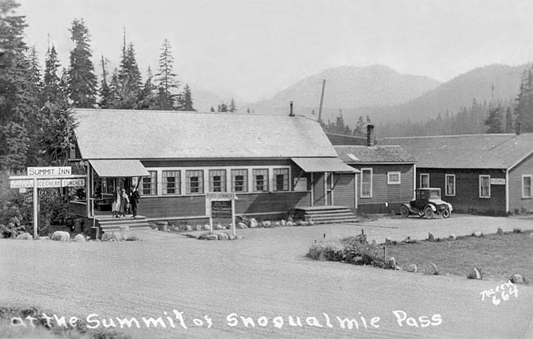
This scene was photographed by John Albert Juleen (1874–1935) in the early to mid 1920s, from the same
location as the previous scene. In 1917 A Geographic Dictionary of Washington still mentioned Laconia as “a
village in Snoqualmie Pass,” a couple years after the abandonment of the old Cascade High Line, but by the
1920s the name Laconia had gone into disuse. By then the facilities at the summit for travelers of the Sunset Highway were
referred to as being at Snoqualmie Pass, rather than as being at Laconia. In 1923 the Sunset Highway was also designated
as State Road No. 2. In this scene the entrance to the Summit Inn is shown in the foreground along the eastbound side of the
Sunset Highway. The Summit Inn was first owned by Jean Paul Holden (1873–1964). The sign shown for the Summit
Inn advertised “Ice-Cream,” “Lunches” and “Plate Dinners 50¢.” Other signs
visible there advertised “Buy the Seattle Star Here,” “Kodak Film” and “Ask for Pure
Sody-Licious Bottled Beverages.” The building shown further down the eastbound side of the road had a sign that
hung out front over the eastbound lane of the Sunset Highway, which said “Summit Garage.” There were also
signs there for Red Crown gasoline and Zerolene motor oil. A tow truck can be seen backed up in front of the garage
building. Off in the distance, to the left behind the garage building, can be seen the framework of the partially dismantled
railroad engine house and turntable facility.

This scene was probably photographed a year or two after the previous scene, sometime in the early to mid 1920s.
The building shown off in the distance near the left edge of the image was the Summit Garage, which had an addition
built perpendicular to the Sunset Highway sometime after the previous scene was photographed. The left side of the
large building shown in the middle foreground of the image faced lengthwise toward where the Laconia railroad yard
used to be located. This building is labeled on the 1913 survey map as the railroad “bunkhouse.” The
largest building shown to the right of the old railroad bunkhouse was the early Summit Inn, shown from the back side.
Shown off in the distance between these two buildings, on the other side of the Sunset Highway, is the other building
that is labeled as a “house” on the 1913 survey map. At the time this scene was photographed, the
bunkhouse, the house, and possibly a few outbuildings, which may have been relocated from nearby, were the few
remaining structures from Laconia and the bygone era of the Cascade High Line. Back then the former railroad bunkhouse
was used as the Summit Inn lodging annex, providing overnight accommodations for travelers of the Sunset Highway.
This scene, photographed in about the early to mid 1920s, shows the early Summit Inn located lengthwise between
the old railroad bunkhouse and the original Sunset Highway, which is shown in the foreground of this image. The front
side of the building was angled toward the eastbound traffic and the front steps of the main entrance were right along
the eastbound side of the road. The old railroad bunkhouse is shown having a “Rooms” sign, since by the
time this scene was photographed it was used as the Summit Inn lodging annex. In 1925 Jean Paul Holden
(1873–1964) sold the Summit Inn to Raymond J. Schneider (1892–1974) and Lena M. Schneider
(1892–1989), who managed the inn until they sold it in 1934 to Marshall Cruce Mason (1882–1953).
On the other side of present-day Interstate 90, across from where the early Summit Inn once was located, a segment of
the original Sunset Highway location still exists as Yellowstone Trail Road, named after the
Yellowstone Trail automobile route. The Yellowstone Trail
was the first designated automobile route across the entire northern part of the United States and beginning in 1915
the route used the original Sunset Highway over Snoqualmie Pass.

This scene was probably photographed about the following winter after the previous scene was photographed. The view is
looking eastbound towards where present-day Interstate 90 now crosses the location of the original Sunset Highway
(see map). Back then the highway was not kept plowed open all
winter and in this scene it appears that only a few automobiles had driven through since the highway was last plowed.
After the highway was relocated in 1928 from the original Sunset Highway location, to the right-of-way of the former
Laconia railroad yard, the Summit Inn was also relocated from that location over to along the westbound side of the
new highway.

This scene was photographed by John Boyd Ellis (1894–1983) and shows the Summit Inn soon after the building was
moved in 1930, from along the original Sunset Highway, over to the new highway constructed on the right-of-way of the former
Laconia railroad yard. The building was moved to the opposite side of the former railroad bunkhouse to a location
along the new highway about one hundred feet westbound from the present location of the Travelers' Rest. The front
side of the building faced toward the new highway and toward where the Laconia Depot and water tank once were located.
The old railroad bunkhouse, shown in this scene located behind the Summit Inn, continued to be used briefly as the
Summit Inn lodging annex. According to Lena Schneider the annex was torn down in the summer of 1931, when they built
four tourist cabins and a house. The new highway (see map) was
constructed in 1928 as State Road No. 2 and it also became part of U.S. Route 10 (US 10). The highway was kept plowed
open all winter beginning in December 1931 and it was first paved over the summit in 1934, before becoming Primary State
Highway 2 (P.S.H. #2) in 1937.

This scene was photographed in about the mid 1930s, soon after the ski hill opened in 1934. The relocated Summit Inn is
shown, on the right, after the old railroad bunkhouse that had been used as the Summit Inn lodging annex had been torn
down and before an addition was attached that about doubled the length of the inn. Some of the same signs are still visible
though, as in years past, advertising “Ice-Cream,” “Lunches” and “Plate Dinners
50¢.” After the ski area began operation Snoqualmie Pass became a very popular winter recreation area for
alpine skiing. As is shown in this image, by about the mid 1930s, the wide right-of-way of the former Laconia railroad yard was
utilized in winter for ski area parking. This same route at the summit of the pass that once was kept plowed open by railroad
double rotary snow plows was by the early 1930s kept plowed open by highway snow plows. The building shown on the left
appears to have possibly been later moved across the highway and attached to the Summit Inn, as the addition shown in the
following image.

This scene shows the relocated Summit Inn on the left and the Travelers' Rest on the right, which was built in 1938
with funding from the Public Works Administration (PWA). After the Summit Inn building was moved to this location it
had an addition attached by about the mid 1930s, which extended about halfway toward the present location of the
Travelers' Rest as is shown above. The front end corners of the angled wings of the Travelers' Rest were located
right up against the edge of the curved 100-foot wide highway right-of-way, 50 feet from centerline. After Interstate 90
was constructed on a different highway alignment through Snoqualmie Pass the older US 10 highway alignment through
Snoqualmie Pass became State Route 906 (SR 906). To construct an approach to the underpass access at the East Summit
Exit of I-90, at Exit 53, the curve of the old highway by the Travelers' Rest was realigned away from the building
by tightening up the curve and the grade was also cut down for vertical realignment to the underpass access. At present
though some concrete panels still exist from the westbound lane of the old highway alignment by the Travelers' Rest
shown above. Except for the existing curve realignment, by the Travelers' Rest, the remainder of the present day
segment of SR 906 through the Summit West area runs right down the former Chicago, Milwaukee & Puget Sound
Railway right-of-way of the old Laconia railroad yard. It was right there that the old high line railroad yard was located. It
was right there that steam locomotive bells and whistles once sounded out through the mountain pass and steam once
billowed skyward through the mountain air. It was right there, many years ago, a place once called Laconia.

Cascade High Line Commemoration - January 2015

<< BACK
|