Maple Valley Depot History
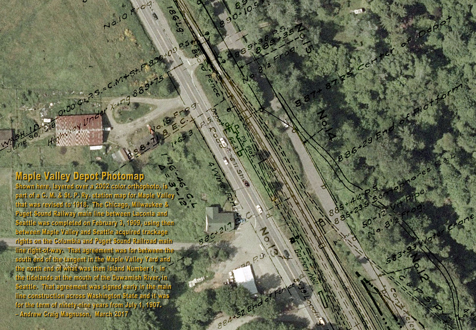
Back from oblivion! This photomap shows the historical location where the two-story Maple
Valley Depot once stood, located in between what are now Renton Maple Valley Road SE (State
Route 169) and the Cedar River Trail. That was the second Maple Valley Depot and it was built
in 1911, according to page 6 of the Railway and Marine News issued on November 1, 1911.
The first Maple Valley Depot was built in 1890, by the Columbia and Puget Sound Railroad,
according to 1890 expenditures charged to construction of the Maple Valley Depot reported in
the 1890-1891 Report to the Stockholders by the Oregon Improvement Company, which at
that time owned and operated the Columbia and Puget Sound Railroad. The Seattle
Post-Intelligencer, on May 15, 1890, on page 12, also noted that Maple Valley was being
made a regular station and when the depot that was then under construction was completed a
telegraph operator and ticket agent would be appointed at the new station. The Columbia and
Puget Sound Railroad at that time was narrow gauge and was widened to standard gauge in 1897,
according to page 721 of The Railway and Engineering Review issued on December 18, 1897.
The first Maple Valley Depot was located between what was then Railroad Avenue and the west
side of the tracks, at the track switch that was located just slightly north from in front of the store of W.D.
Gibbon on the track alongside Railroad Avenue. Old photographs and the 1907 plat map of Maple
Valley reveal that the first Maple Valley Depot was located where Renton Maple Valley Road SE is
now located in front of the paved area between Maple Valley Market and the Shell gas station. Where
Renton Maple Valley Road SE now curves through there, south of State Route 18, the present road
location was once where the south part of the Columbia and Puget Sound Railroad yard was located.
A railroad section house, trackside water tank, and bunkhouse were all located along the east side of
the railroad yard along what is now the east side of Renton Maple Valley Road SE. The railroad
section house was located across from where the Shell gas station is now located and the water tank
and railroad bunkhouse were located just slightly north of there. That general area, on the north side of
the Cedar River, was the original old town of Maple Valley. A busy four-lane divided highway section of
State Route 18 now crosses less than four hundred feet to the south of the area shown in this
photomap. The depot shown on the photomap was used by both the Columbia and Puget Sound
Railroad and also by the Chicago, Milwaukee & Puget Sound Railway. Both railroads eventually
later changed names. The Columbia and Puget Sound Railroad was renamed, on March 20, 1916,
as the Pacific Coast Railroad. The Chicago, Milwaukee & Puget Sound Railway was
consolidated, on January 1, 1913, back into the Chicago, Milwaukee and St. Paul Railway. When the
second, two-story, Maple Valley Depot was first built Joint Agent John A. McEachern had his living
quarters upstairs on the second floor, according to page 1689 of The Railroad Telegrapher
issued in September 1911. His daughter, Flora McEachern, a few years later became an operator
for the Columbia and Puget Sound Railroad. John A. McEachern had previously been a depot agent
at Gilman (now Issaquah), according to the 1892 Washington State Census and page 12 of The
Seattle Post-Intelligencer issued on February 21, 1892. The photomap indicates that the depot
measured 18′ wide by 56.3′ long and apparently at the time had an attached
8′ wide by 11′ long shed on the south end. The depot shed was probably below the
track level elevation. The depot and at least part of the back of its trackside loading platform were
supported up at the track level elevation on timber posts and beams on the railroad fill embankment,
which on grade was over 10′ higher than the ground underneath the back wall of the depot.
The photomap shows that the planked loading platform ran along the entire front of the depot and
apparently at the time for nearly 200′ along the railroad tracks. The tracks occupied by the
Chicago, Milwaukee and St. Paul Railway are shown on the photomap as double solid lines and
the tracks occupied by the Columbia and Puget Sound Railroad, or Pacific Coast Railroad, are
shown as double dashed lines. The track shown veering off to the east, crossing what is now
Maxwell Road SE, went to Hobart and Taylor. The Chicago, Milwaukee and St. Paul Railway
passing track began on the transcontinental main line eastbound from the depot about 1378 feet
and the siding began on the passing track about 215 feet westbound from there. The two tracks
closest to the depot were at the north end of the Columbia and Puget Sound Railroad yard, where
on the south end their main line crossed over the Cedar River and continued on through Black
Diamond. The single dashed line shown running along the front of the depot represents a 1″
diameter water pipe that at the time supplied domestic water to the depot, all the way from a tall
tankhouse style water tower about 1700′ away that stood in town behind the back northwest
corner of the store of W.D. Gibbon that was located along the west side of Railroad Avenue. On the
photomap the depot train order semaphore signal is shown out in front of the operator's bay.
Semaphore signals and a battery well are also shown at STA 885+23.5. Also shown is a 5 span
pile trestle, identified as FF 144½, spanning over what is now the SE 212th Street under
crossing at STA 889+75. Across the railroad tracks from the depot, along what is now Maxwell
Road SE, are shown the telegraph lines and poles of the Continental Telegraph Company, which
had a telegraph line that hung over the railroad tracks to a pole by the north end of the depot. The
Continental Telegraph Company was controlled by the Chicago, Milwaukee and St. Paul Railway
and had telegraph lines in Washington, Idaho, Montana, North Dakota, and South Dakota. Also a
water crane, or standpipe, is shown at STA 883+93. Shown across the tracks from the water
crane is also an 8′ wide by 39′ long loading platform. The water crane was
pressurized by a 950′ long by 12″ diameter wood-stave underground water pipe
that ran along the railroad tracks, from a standard 16′ staved by 24′ diameter
(50,000 gallon) water tank that was located near the main part of town along the railroad at STA
874+98 and was filled by a 3½″ diameter supply pipe. Northeast of that water tank,
across the county road from the Milwaukee tracks, were once the Milwaukee Hotel and the
Milwaukee Bar along the east side of the road that is now Maxwell Road SE. Farther north, along
the east side of that road, were the Hotel Seattle and a blacksmith shop. The other water tank,
located trackside in the Columbia and Puget Sound Railroad yard between the railroad section
house and bunkhouse, was also a 16′ staved by 24′ diameter water tank and it
was located less than 150′ to the south-southwest from the north water tank. After the
Pacific Coast Railroad was purchased by the Great Northern Railway, in the early 1950's,
a small third depot having a single slope shed roof was built about 70 feet eastbound from the
second depot, which was then torn down. These are a few details that have mostly disappeared
from the landscape, but not so inevitably from map and photographic records from the past.
<< BACK
 Andrew Craig Magnuson
Forks, Washington
March 31, 2017
|