 Seattle-Everett Interurban Railway
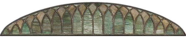
The above scene shows three interurban electric trolley cars of the Seattle-Everett Traction Company, shortly before these trolley cars initially went into service in 1910. When new, these interurban trolley cars were rather luxurious inside, having fine woodwork and high-back leather bench seats. Over the passenger windows were arched, leaded, opalescent glass panels (shown above). 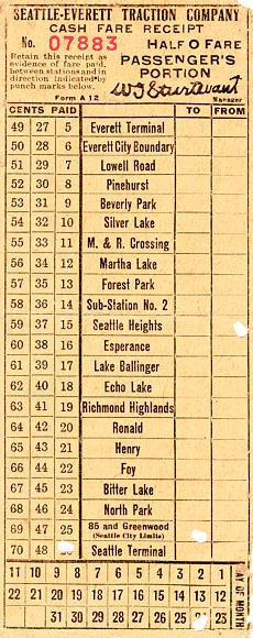
I grew up in the Ridgecrest neighborhood within the area that later became the City of Shoreline. I lived about a mile from where the Seattle-Everett Interurban Railway used to cross on an overpass bridge over old US 99 at North 155th Street. By my time, the interurban railway had already been abandoned for 20 years and only the grade was still partially evident and used mainly as a power line corridor. While stuck in traffic at the intersection of Aurora Avenue North (US 99) and North 155th Street, I would sometimes look at an old landmark on the southwest corner of the intersection. The old landmark was a lone concrete bridge abutment, one of the only extant relics in the area from the old interurban railway, other than the grade itself. While looking at the old weathered bridge abutment (demolished in late November 2005), I would sometimes wonder about the history of the interurban railway. At that time, I never realized that the long gone interurban overpass bridge had been known as the Pershing Bridge. The Pershing Bridge had been a steel plate half-through-girder bridge that was built in 1926 and had spanned over US 99 between a pair of concrete bridge abutments. Prior to 1926, a shorter interurban bridge had spanned over the road there, when the road was narrower and was known as the North Trunk Road [1]. The North Trunk Road extended to the north, for 6.13 miles (STA 0+00 to STA 323+83.10), between the north city limits of Seattle (then at N 85th Street) and the Snohomish County line. The road was paved, in 1913, with No. 2 brick acquired from the Denny-Renton Clay & Coal Company and it eventually became part of a main automobile route between Seattle and Everett. During the time of the interurban railway, there used to be a small rural interurban station that was also known as Pershing, which was located just north of the Pershing Bridge. The railroad bridge and the station were named after General John J. Pershing, in honor of the celebrated World War I general. Pershing Station was located on the west side of the track, on the north bridge approach embankment. Old photographs reveal that Pershing Station was a wooden, rectangular, shed-sized station with a ridged roof, the gabled ends of which faced each way down the track. The station had no windows, just an open front that faced the track. A planked loading deck extended between the front of the station and the track and to the south along the track for about the length of a trolley car, nearly reaching the north end of the Pershing Bridge. Pershing Station wasn't added as a stop until sometime after World War I. The early fare receipt ticket above shows that originally there were no stops between Foy Station by present-day North 145th Street and Henry Station by present-day North 165th Street. Old maps reveal that Henry Station was located on the west side of the track, just south of present-day North 165th Street. Headed northbound, Henry Station was 0.49 miles beyond Pershing Station and 0.54 miles before Ronald Station, which was located on the west side of the track, just north of present-day North 175th Street. Sometime before 1927, Henry Station was renamed Maywood Station, probably after the Maywood Acre Tracts that the interurban line ran through just north of that station. Henry Station was undoubtedly named after Horace Chapin Henry, the prominent Seattle railroad construction contractor, businessman and philanthropist, who in 1910 donated 34 acres of land only about 1.5 miles from Henry Station for starting the Firland tuberculosis hospital. He also donated some of the funding for starting that facility. At the time that the Seattle-Everett Interurban Railway began operation, Horace Chapin Henry had just completed about a year earlier the construction of the Chicago, Milwaukee & Puget Sound Railway main line railroad grade all the way across eastern Washington and up through the Cascade Mountains over Snoqualmie Pass and on down to Tacoma, as the principal construction contractor for clearing, grading and bridging that section of the railroad's Pacific Coast extension. Also, about six weeks before the Seattle-Everett Interurban Railway began operation, Horace C. Henry had just been awarded the contract to construct the railroad grade for the Everett branch line of the Chicago, Milwaukee & Puget Sound Railway through the Snoqualmie and Snohomish River Valleys.
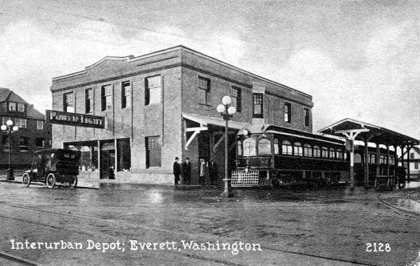
The trolleys shown in the first picture at the beginning of this article are three of six trolley cars, numbered 50-55, built about 1910 for the Seattle-Everett Traction Company, by the Niles Car & Manufacturing Company, of Niles, Ohio. The front trolley car in the first picture is Car 55, which has been rebuilt and is now on display at Heritage Park in Lynnwood, Washington. Shown in the picture above, also from about 1910, are two Niles trolley cars at the Seattle-Everett Interurban station at the northwest corner of Pacific Avenue and Colby Avenue in Everett, Washington. Besides Car 55, the only other Niles trolley car remaining from the Seattle-Everett Interurban Railway is Car 53, which has been converted into a diner in eastern Washington. The Seattle-Everett Traction Company became the Pacific Northwest Traction Company in 1912, and then became the North Coast Transportation Company in 1930. As the interurban service changed names, from various mergers, the six trolleys built by the Niles Car & Manufacturing Company continued to provide electric rail service from 1910 until the Seattle-Everett Interurban Railway was abandoned in 1939. Footnote:
 Andrew Craig Magnuson
Forks, Washington December 10, 2005
Copyright © by Andrew Craig Magnuson |