Trail Notes

Hoh Lake and Bogachiel Peak Hike – September 14–16, 2012
 I hiked to Hoh Lake for the weekend,
starting from the Sol Duc trailhead and taking the Canyon Creek trail from the junction near
Sol Duc Falls. Friday evening I camped at Deer Lake located 3.4 miles from the Sol Duc
trailhead. Saturday morning I departed Deer Lake taking the Bogachiel trail from where it runs
by the head of the lake. From that trail junction the trail continues past the group of tarns
known as the Potholes and then on up to the ridgeline that separates the Sol Duc and Bogachiel
drainages. After crossing over onto the Bogachiel side of the ridge the trail goes side hill to
the Seven Lakes Basin trail junction, 7.1 miles from the Sol Duc trailhead. From there the trail
continues on to High Divide junction, which is located on a narrow part of the ridgeline separating
the Bogachiel and Hoh drainages where the ridgeline joins to Bogachiel Peak just below its summit.
While hiking along the trail through the upper Bogachiel drainage, I saw three Black bears busily
foraging for huckleberries. High Divide junction is 7.9 miles from the Sol Duc trailhead and is
where the Bogachiel Trail ends. It's also where the High Divide trail heads east to Heart Lake
and where the Hoh Lake trail heads south to Hoh Lake and to the Hoh River. From High Divide
junction the Hoh Lake trail takes off on the narrow ridgeline that is not much wider than the
trail and then immediately crosses over onto the Hoh drainage side of the ridge and descends to Hoh
Lake in 1.25 miles for a total of about 9.2 miles from the Sol Duc trailhead.
I hiked to Hoh Lake for the weekend,
starting from the Sol Duc trailhead and taking the Canyon Creek trail from the junction near
Sol Duc Falls. Friday evening I camped at Deer Lake located 3.4 miles from the Sol Duc
trailhead. Saturday morning I departed Deer Lake taking the Bogachiel trail from where it runs
by the head of the lake. From that trail junction the trail continues past the group of tarns
known as the Potholes and then on up to the ridgeline that separates the Sol Duc and Bogachiel
drainages. After crossing over onto the Bogachiel side of the ridge the trail goes side hill to
the Seven Lakes Basin trail junction, 7.1 miles from the Sol Duc trailhead. From there the trail
continues on to High Divide junction, which is located on a narrow part of the ridgeline separating
the Bogachiel and Hoh drainages where the ridgeline joins to Bogachiel Peak just below its summit.
While hiking along the trail through the upper Bogachiel drainage, I saw three Black bears busily
foraging for huckleberries. High Divide junction is 7.9 miles from the Sol Duc trailhead and is
where the Bogachiel Trail ends. It's also where the High Divide trail heads east to Heart Lake
and where the Hoh Lake trail heads south to Hoh Lake and to the Hoh River. From High Divide
junction the Hoh Lake trail takes off on the narrow ridgeline that is not much wider than the
trail and then immediately crosses over onto the Hoh drainage side of the ridge and descends to Hoh
Lake in 1.25 miles for a total of about 9.2 miles from the Sol Duc trailhead.
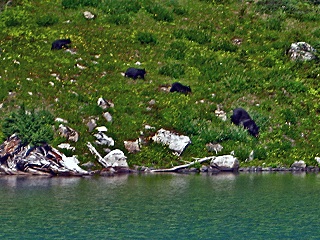 When nearing the lake I saw from an overlook, where the trail emerges from the timber, four bears
at one time foraging for huckleberries across the lake on the south facing slope above the north
shore. Shortly after arriving at the lakeshore by the outlet, where about a dozen rock slab steps
descend to the water's edge, I saw a sow bear followed by three cubs rounding the lake from by the
coarse talus on the west end of the lake to the meadow below the patch of timber across the lake
from the outlet. After heading to the water briefly, the four bears went up through the meadow and
disappeared into the patch of timber. I saw for sure at least a total of eight bears at Hoh Lake,
including the three cubs, but two people that arrived there a couple days before I did said that
they had already seen at one time a total of ten bears around the lake. I enjoyed that sunny
Saturday watching the bears forage for huckleberries that afternoon and camped that night in a
campsite at the end of a short trail running down to inside the edge of the timber on the west side
of Hoh Creek just below the outlet of the lake. The next morning, I broke camp and sat for a while
at the foot of the rock slab steps down to the lakeshore by the east side of the outlet. From there
I watched the bears again and tried to fully absorb into a few last moments in time the wildness
and beauty of the place, before slinging my old Kelty backpack back on and heading back out to
civilization. I made one last stop though on the way back out, hiking up to the top of 5,474-foot
Bogachiel Peak from where I enjoyed the view of upper Seven Lakes Basin, High Divide, and over to
Mount Olympus.
When nearing the lake I saw from an overlook, where the trail emerges from the timber, four bears
at one time foraging for huckleberries across the lake on the south facing slope above the north
shore. Shortly after arriving at the lakeshore by the outlet, where about a dozen rock slab steps
descend to the water's edge, I saw a sow bear followed by three cubs rounding the lake from by the
coarse talus on the west end of the lake to the meadow below the patch of timber across the lake
from the outlet. After heading to the water briefly, the four bears went up through the meadow and
disappeared into the patch of timber. I saw for sure at least a total of eight bears at Hoh Lake,
including the three cubs, but two people that arrived there a couple days before I did said that
they had already seen at one time a total of ten bears around the lake. I enjoyed that sunny
Saturday watching the bears forage for huckleberries that afternoon and camped that night in a
campsite at the end of a short trail running down to inside the edge of the timber on the west side
of Hoh Creek just below the outlet of the lake. The next morning, I broke camp and sat for a while
at the foot of the rock slab steps down to the lakeshore by the east side of the outlet. From there
I watched the bears again and tried to fully absorb into a few last moments in time the wildness
and beauty of the place, before slinging my old Kelty backpack back on and heading back out to
civilization. I made one last stop though on the way back out, hiking up to the top of 5,474-foot
Bogachiel Peak from where I enjoyed the view of upper Seven Lakes Basin, High Divide, and over to
Mount Olympus.
Lake Angeles Hike – September 30, 2012
 The morning following the harvest moon I woke up to what promised to be a beautiful sunny autumn
day on the last day of September. I decided to make the most of the weather and go for a hike,
knowing there wouldn't be many more weekends like this before the rainy season began and before
the snow started to fall in the high country. It was a day just meant to be spent outdoors in the
mountains enjoying the autumn colors and maybe even finding some late-season huckleberries in the
higher elevations. I decided to hike up to
Lake Angeles, since I had just been beckoned that morning by the nice weather to go on an
impromptu hike and that trail is perfect for a late start, being only about 3.7 miles long. Late
morning, I got to the trailhead parking lot at the end of the road that takes off on the right side
of the Hurricane Ridge road, just before the park entrance station by the Heart O' the Hills
Campground. I headed up the trail, which first goes up the Ennis Creek drainage and then crosses
the creek in a little over a mile. The trail from the Ennis Creek crossing continues up around a
ridge and then across the upper reaches of a tributary to Ennis Creek. The trail then climbs up a
ridge through the dense, dark, forest stand and crosses over into the upper Lake Creek drainage.
Along the way I saw a cluster of pinedrops growing beside the trail, which is a plant well suited
to growing in dark forest stands since it lacks chlorophyll for photosynthesis anyway. Pinedrops
(Pterospora andromedea) are unique in that they are a reddish colored obligate myco-heterotrophic
plant that are in a monotypic genus that includes only that single species. By early afternoon I
arrived at the approximately 20-acre lake and enjoyed from a sunny spot the view across the
sparkling waters to the shadowy cirque headwall that loomed as a dark backdrop to the brightly
backlit island out near the middle of the lake. The island almost appeared to float on the emerald
mirror-like water beneath the sheer cliffs and reflected nearly perfectly on the water. Before
heading back out I hiked along a fisherman's trail along the west shore of the lake, which lead to
a few small openings along the lakeshore where the thick vegetation otherwise grows right down to
the water's edge. Driving back home I was surprised by an encore performance of the harvest moon,
which still visually appeared to be completely full for a second night showing, even though
astronomically it had already culminated the night before. The spectacular moonrise over the east
end of Lake Crescent, viewed from
Meldrim Point, was in perfect alignment right between the lower flanks of Pyramid Peak and Storm
King Mountain. The bright moon illuminated the water with its moonbeam in a narrow undulating
reflection that stretched nearly all the way across the surface of the lake. It was a perfect
ending for the last day of September.
The morning following the harvest moon I woke up to what promised to be a beautiful sunny autumn
day on the last day of September. I decided to make the most of the weather and go for a hike,
knowing there wouldn't be many more weekends like this before the rainy season began and before
the snow started to fall in the high country. It was a day just meant to be spent outdoors in the
mountains enjoying the autumn colors and maybe even finding some late-season huckleberries in the
higher elevations. I decided to hike up to
Lake Angeles, since I had just been beckoned that morning by the nice weather to go on an
impromptu hike and that trail is perfect for a late start, being only about 3.7 miles long. Late
morning, I got to the trailhead parking lot at the end of the road that takes off on the right side
of the Hurricane Ridge road, just before the park entrance station by the Heart O' the Hills
Campground. I headed up the trail, which first goes up the Ennis Creek drainage and then crosses
the creek in a little over a mile. The trail from the Ennis Creek crossing continues up around a
ridge and then across the upper reaches of a tributary to Ennis Creek. The trail then climbs up a
ridge through the dense, dark, forest stand and crosses over into the upper Lake Creek drainage.
Along the way I saw a cluster of pinedrops growing beside the trail, which is a plant well suited
to growing in dark forest stands since it lacks chlorophyll for photosynthesis anyway. Pinedrops
(Pterospora andromedea) are unique in that they are a reddish colored obligate myco-heterotrophic
plant that are in a monotypic genus that includes only that single species. By early afternoon I
arrived at the approximately 20-acre lake and enjoyed from a sunny spot the view across the
sparkling waters to the shadowy cirque headwall that loomed as a dark backdrop to the brightly
backlit island out near the middle of the lake. The island almost appeared to float on the emerald
mirror-like water beneath the sheer cliffs and reflected nearly perfectly on the water. Before
heading back out I hiked along a fisherman's trail along the west shore of the lake, which lead to
a few small openings along the lakeshore where the thick vegetation otherwise grows right down to
the water's edge. Driving back home I was surprised by an encore performance of the harvest moon,
which still visually appeared to be completely full for a second night showing, even though
astronomically it had already culminated the night before. The spectacular moonrise over the east
end of Lake Crescent, viewed from
Meldrim Point, was in perfect alignment right between the lower flanks of Pyramid Peak and Storm
King Mountain. The bright moon illuminated the water with its moonbeam in a narrow undulating
reflection that stretched nearly all the way across the surface of the lake. It was a perfect
ending for the last day of September.
Elk Mountain Hike – September 14, 2013
 I had decided the day before to go on a hike to
Elk Mountain along the Grand Ridge
trail in the rain shadow of the Olympic Mountains, since a morning marine cloud layer had been
blanketing the coast the last couple days. When I left Forks the marine cloud layer persisted and
when I got to Lake Crescent the upper two-thirds of the peaks around the lake were obscured by
clouds. When I got to Indian Valley, some blue sky showed through some breaks in the clouds, but as
I drove onward up out of the Elwha Valley toward Port Angeles I drove into some fog. When I got to
Port Angeles, I drove up the Hurricane Ridge road and finally broke through the marine cloud layer
and into the beautiful sunshine above, leaving behind the gray blanket of clouds. At Hurricane
Ridge I drove out to the end of the winding gravel Obstruction Point road. The Grand Ridge
trailhead is located there at 6150 feet in elevation and from there traverses 7.4 miles across to
the trailhead at the other end of the Grand Ridge trail at 5400 feet in elevation by the Deer Park
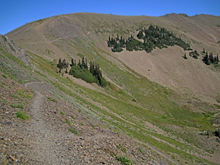
Campground. From the end of the Obstruction Point road the Grand Ridge trail first skirts around
the east side of Obstruction Peak, going past the junction with the Badger Valley trail in about
0.2 miles. The trail then continues steeply up the barren south slope of Elk Mountain reaching the
junction with the Elk Mountain way trail at about 2.0 miles from the trailhead. The Elk Mountain
way trail is a tie that from the Grand Ridge trail drops steeply down to the Badger Valley trail
in about 1.3 miles. The junction of the Grand Ridge trail with the Elk Mountain way trail is
located at an elevation of about 6600 feet and is on the highest elevation segment of designated
trail in Olympic National Park. From by this trail junction I climbed less than 200 feet in
elevation up to the ridgeline above the trail junction and then over to the summit of Elk Mountain
less than 0.25 mile to the east. Marking the summit is a triangulation station survey monument that
is stamped “ELK MTN.”
I had decided the day before to go on a hike to
Elk Mountain along the Grand Ridge
trail in the rain shadow of the Olympic Mountains, since a morning marine cloud layer had been
blanketing the coast the last couple days. When I left Forks the marine cloud layer persisted and
when I got to Lake Crescent the upper two-thirds of the peaks around the lake were obscured by
clouds. When I got to Indian Valley, some blue sky showed through some breaks in the clouds, but as
I drove onward up out of the Elwha Valley toward Port Angeles I drove into some fog. When I got to
Port Angeles, I drove up the Hurricane Ridge road and finally broke through the marine cloud layer
and into the beautiful sunshine above, leaving behind the gray blanket of clouds. At Hurricane
Ridge I drove out to the end of the winding gravel Obstruction Point road. The Grand Ridge
trailhead is located there at 6150 feet in elevation and from there traverses 7.4 miles across to
the trailhead at the other end of the Grand Ridge trail at 5400 feet in elevation by the Deer Park
Campground. From the end of the Obstruction Point road the Grand Ridge trail first skirts around
the east side of Obstruction Peak, going past the junction with the Badger Valley trail in about
0.2 miles. The trail then continues steeply up the barren south slope of Elk Mountain reaching the
junction with the Elk Mountain way trail at about 2.0 miles from the trailhead. The Elk Mountain
way trail is a tie that from the Grand Ridge trail drops steeply down to the Badger Valley trail
in about 1.3 miles. The junction of the Grand Ridge trail with the Elk Mountain way trail is
located at an elevation of about 6600 feet and is on the highest elevation segment of designated
trail in Olympic National Park. From by this trail junction I climbed less than 200 feet in
elevation up to the ridgeline above the trail junction and then over to the summit of Elk Mountain
less than 0.25 mile to the east. Marking the summit is a triangulation station survey monument that
is stamped “ELK MTN.”
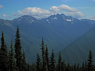
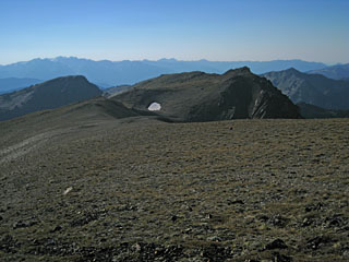 I spent the remainder of the afternoon enjoying from the mountaintop the sunshine and the view,
which included Mount Olympus, Lillian Ridge, Grand Lake, Moose Lake, Mount Deception, The Needles
and over to Blue Mountain beyond the end of Grand Ridge. The Strait of Juan de Fuca remained
blanketed in the low-level marine cloud layer far below that slowly receded like a tide, eventually
revealing some of the lowlands to the north. On the mountaintop a couple small birds pecked about
in tandem for seeds or insects in the short sparse ground vegetation growing among the lichen
encrusted rocks and splintery shale. A hawk soared by and circled around a couple times in the
gusty warm breeze and then glided off somewhere else. The only sounds were that of the wind and a
few insects that buzzed about. As the sun began to sink low and the late summer haze on the horizon
began to turn to a faint dusky rose color, I headed back down from the mountaintop to the trail so
that I could get back to the trailhead before it got too late. On the way back out along the trail,
the south slope of Elk Mountain took on a golden hue as the sun sunk lower. As I rounded the trail
from the west end of Elk Mountain towards Obstruction Peak, the setting sun backlit with a golden
aura the silhouette of a rock outcrop above the trail on the north end of the gap just north of
Obstruction Peak. As I passed the Badger Valley trail junction and neared the trailhead at
Obstruction Point, the moon loomed over the north end of Lillian Ridge in the fading twilight. When
I got back to the trailhead, I packed up my truck and then rattled back out over the rough 8 mile
gravel road in the dark, thinking it had been a perfect day. Back home, the next day brought
thundershowers to Forks and I was glad that I had spent a sunny afternoon on a mountaintop.
I spent the remainder of the afternoon enjoying from the mountaintop the sunshine and the view,
which included Mount Olympus, Lillian Ridge, Grand Lake, Moose Lake, Mount Deception, The Needles
and over to Blue Mountain beyond the end of Grand Ridge. The Strait of Juan de Fuca remained
blanketed in the low-level marine cloud layer far below that slowly receded like a tide, eventually
revealing some of the lowlands to the north. On the mountaintop a couple small birds pecked about
in tandem for seeds or insects in the short sparse ground vegetation growing among the lichen
encrusted rocks and splintery shale. A hawk soared by and circled around a couple times in the
gusty warm breeze and then glided off somewhere else. The only sounds were that of the wind and a
few insects that buzzed about. As the sun began to sink low and the late summer haze on the horizon
began to turn to a faint dusky rose color, I headed back down from the mountaintop to the trail so
that I could get back to the trailhead before it got too late. On the way back out along the trail,
the south slope of Elk Mountain took on a golden hue as the sun sunk lower. As I rounded the trail
from the west end of Elk Mountain towards Obstruction Peak, the setting sun backlit with a golden
aura the silhouette of a rock outcrop above the trail on the north end of the gap just north of
Obstruction Peak. As I passed the Badger Valley trail junction and neared the trailhead at
Obstruction Point, the moon loomed over the north end of Lillian Ridge in the fading twilight. When
I got back to the trailhead, I packed up my truck and then rattled back out over the rough 8 mile
gravel road in the dark, thinking it had been a perfect day. Back home, the next day brought
thundershowers to Forks and I was glad that I had spent a sunny afternoon on a mountaintop.
Ansel Adams in Olympic National Park – August 29, 2016
 A hiking activity that I enjoy is locating where old scenic photographs were shot in the mountains.
It's fun because it's challenging and involves both some research and on the ground
exploring and it sometimes results in piecing together some history that may not have been known.
It usually involves first studying an old photograph to find clues, such as prominent topographic
features that can be located. If a few identifiable landmarks are visible in a photograph then the
location from which a scene was photographed can first be approximately determined from maps and
aerial photos. By later walking around in that general location, while looking at an old photograph
and using spatial perception and reasoning, it is possible to “sight in” the horizontal
and vertical alignment or separation of features that are at different distances, to “zero in
on” where a scene was photographed from. If there are close foreground features that are
identifiable in the photograph, which still exist and are still recognizable on site, then the
location can be determined precisely on the ground. Thinking about the centennial anniversary of
the National Park Service, which was last Thursday, prompted me to go find where a scene was
photographed by Ansel Adams, in 1948, in Olympic National Park. The scene is pictured on page 40 in
the book titled Ansel Adams: Our National Parks, published in 1992. Adding to the challenge
the picture in that book has an incorrect caption that says “From Hurricane Hill, Olympic
National Park, Washington, 1948.” That photograph has actually had the same incorrect caption
for over 65 years, since when it was first included as Plate 20 in the Ansel Adams book titled
My Camera in the National Parks: 30 photographs with interpretative text and informative
material on the Parks and Monuments and photographic data, published in 1950. Ansel Adams
actually did photograph, in 1948, a scene from Hurricane Hill that is noted as such in his
Portfolio Number Two: The National Parks & Monuments, 15 Photographs by Ansel Adams. The
photograph from Hurricane Hill included in that rare portfolio of fifteen limited edition
photographs is not the same scene pictured in the two previously mentioned books though. The scene
really photographed from Hurricane Hill was shot from along the north edge of the ridgeline about
150 yards east-southeast of the 5757-foot summit of Hurricane Hill and is a view looking northwest,
over the Griff Creek, Elwha River, and Indian Creek drainages, out toward Crescent Bay on the
Strait of Juan de Fuca. I had first seen the other picture, from the two previously mentioned
books, several years ago and had wondered then where it was actually photographed. I didn't
recognize the mountains in that picture as those visible from Hurricane Hill. After looking at some
digital images of the Olympic Mountains, a few days ago, I identified the prominent mountain shown
in the picture in the two books as Mount Walkinshaw, photographed from somewhere over on 6007-foot
Blue Mountain. As the crow flies, Blue Mountain is actually well over a dozen miles east-southeast
of Hurricane Hill. Studying several 7.5-minute (1:24000-scale) USGS quadrangle maps that day
revealed that the scene is looking across the Gray Wolf River valley and shown, from left to right,
is Point 7076 of Gray Wolf Ridge, Mount Walkinshaw, and mostly hidden behind it is Mount Clark and
The Needles running back toward Mount Deception. Having already figured that out, from home, it was
time today to head over to Blue Mountain to hike around and have some fun figuring out, on the
ground, where Ansel Adams actually photographed that scene 68 years ago. Having seen compelling
black and white photographs by Ansel Adams was partly what got me into developing and printing, in
a darkroom, my own black and white film and photographs, in the 1970's. I also used the same
types of camera lens filters made for black and white photography that he sometimes used. As I
drove on the narrow, winding, road up Blue Mountain, which eventually climbs to over 5800 feet, I
wondered if Ansel Adams drove his 1946 Pontiac Silver Streak Station Wagon up there. I had seen a
couple pictures of that “woody” station wagon, with his added photographer's
platform mounted over the entire roof. Back then, in 1948, the road up Blue Mountain climbed all
the way up to about 6000 feet, to the circa 1931 fire lookout that was then on top of the mountain.
Now about the last couple hundred feet of elevation gain to the top is part of the half-mile Rain
Shadow Loop Trail and the fire lookout has been gone for over 45 years. When I reached the Deer
Park Campground I parked and walked around there and along the upper end of the Three Forks Trail,
from the trailhead in the campground, but nothing there fit the scene. Today, just like when Ansel
Adams visited, a procession of clouds drifted along the mountaintops. A slight haze from a few
lightning strike fires, burning in the park, also somewhat obscured visibility of distant fine
details. Having not found the right Ansel Adams photo location yet I walked up the road that
continues up Blue Mountain, along the road segment above the Deer Park Campground to the first road
switchback. At first I thought Ansel Adams' scene was photographed from that road switchback
that curved left, just over one-quarter mile up the road from the campground, but I soon realized
that the trees there were smaller and nearer than those shown in the photograph. I then walked back
down the road and found what appears to be the right location, back down the road about 150 yards
toward the Deer Park Campground from the road switchback. Of course the patch of trees in the
foreground would be nearly 70 years older and would have changed somewhat, but it appears to be the
right location. On other photo locations that I have found, at high elevations, some foreground
trees have hardly grown at all in 80-100 years and other neighboring trees, within the same
immediate foreground view, have sometimes either grown a lot or have completely disappeared.
Sometimes, on individual trees that have grown slowly, even the same tree limbs and forked tops are
identifiable nearly a century later. Anyway, the spot that I found appears to be about the right
location. The foreground trees have changed somewhat, but that is to be expected. The best proof is
actually evident while looking at the distant ridges, one rising beyond another, shown on the right
side of the picture in the two books. The vertical separation between ridgelines on consecutive
ridges appears to be correct and the horizontal separation between features on consecutive ridges
also appears to be correct. I had a lot of fun solving this outdoor puzzle by hiking around on Blue
Mountain on a nice summer day and that's what really matters, but it was also satisfying to
finally correct some historical information about one of the only few photographs of Olympic
National Park by Ansel Adams that has ever been published. While I was up on Blue Mountain I also
hiked the Rain Shadow Loop Trail, to the former fire lookout site on top, before I headed back down
to my vehicle and drove back down the mountain, headed for another busy week.
A hiking activity that I enjoy is locating where old scenic photographs were shot in the mountains.
It's fun because it's challenging and involves both some research and on the ground
exploring and it sometimes results in piecing together some history that may not have been known.
It usually involves first studying an old photograph to find clues, such as prominent topographic
features that can be located. If a few identifiable landmarks are visible in a photograph then the
location from which a scene was photographed can first be approximately determined from maps and
aerial photos. By later walking around in that general location, while looking at an old photograph
and using spatial perception and reasoning, it is possible to “sight in” the horizontal
and vertical alignment or separation of features that are at different distances, to “zero in
on” where a scene was photographed from. If there are close foreground features that are
identifiable in the photograph, which still exist and are still recognizable on site, then the
location can be determined precisely on the ground. Thinking about the centennial anniversary of
the National Park Service, which was last Thursday, prompted me to go find where a scene was
photographed by Ansel Adams, in 1948, in Olympic National Park. The scene is pictured on page 40 in
the book titled Ansel Adams: Our National Parks, published in 1992. Adding to the challenge
the picture in that book has an incorrect caption that says “From Hurricane Hill, Olympic
National Park, Washington, 1948.” That photograph has actually had the same incorrect caption
for over 65 years, since when it was first included as Plate 20 in the Ansel Adams book titled
My Camera in the National Parks: 30 photographs with interpretative text and informative
material on the Parks and Monuments and photographic data, published in 1950. Ansel Adams
actually did photograph, in 1948, a scene from Hurricane Hill that is noted as such in his
Portfolio Number Two: The National Parks & Monuments, 15 Photographs by Ansel Adams. The
photograph from Hurricane Hill included in that rare portfolio of fifteen limited edition
photographs is not the same scene pictured in the two previously mentioned books though. The scene
really photographed from Hurricane Hill was shot from along the north edge of the ridgeline about
150 yards east-southeast of the 5757-foot summit of Hurricane Hill and is a view looking northwest,
over the Griff Creek, Elwha River, and Indian Creek drainages, out toward Crescent Bay on the
Strait of Juan de Fuca. I had first seen the other picture, from the two previously mentioned
books, several years ago and had wondered then where it was actually photographed. I didn't
recognize the mountains in that picture as those visible from Hurricane Hill. After looking at some
digital images of the Olympic Mountains, a few days ago, I identified the prominent mountain shown
in the picture in the two books as Mount Walkinshaw, photographed from somewhere over on 6007-foot
Blue Mountain. As the crow flies, Blue Mountain is actually well over a dozen miles east-southeast
of Hurricane Hill. Studying several 7.5-minute (1:24000-scale) USGS quadrangle maps that day
revealed that the scene is looking across the Gray Wolf River valley and shown, from left to right,
is Point 7076 of Gray Wolf Ridge, Mount Walkinshaw, and mostly hidden behind it is Mount Clark and
The Needles running back toward Mount Deception. Having already figured that out, from home, it was
time today to head over to Blue Mountain to hike around and have some fun figuring out, on the
ground, where Ansel Adams actually photographed that scene 68 years ago. Having seen compelling
black and white photographs by Ansel Adams was partly what got me into developing and printing, in
a darkroom, my own black and white film and photographs, in the 1970's. I also used the same
types of camera lens filters made for black and white photography that he sometimes used. As I
drove on the narrow, winding, road up Blue Mountain, which eventually climbs to over 5800 feet, I
wondered if Ansel Adams drove his 1946 Pontiac Silver Streak Station Wagon up there. I had seen a
couple pictures of that “woody” station wagon, with his added photographer's
platform mounted over the entire roof. Back then, in 1948, the road up Blue Mountain climbed all
the way up to about 6000 feet, to the circa 1931 fire lookout that was then on top of the mountain.
Now about the last couple hundred feet of elevation gain to the top is part of the half-mile Rain
Shadow Loop Trail and the fire lookout has been gone for over 45 years. When I reached the Deer
Park Campground I parked and walked around there and along the upper end of the Three Forks Trail,
from the trailhead in the campground, but nothing there fit the scene. Today, just like when Ansel
Adams visited, a procession of clouds drifted along the mountaintops. A slight haze from a few
lightning strike fires, burning in the park, also somewhat obscured visibility of distant fine
details. Having not found the right Ansel Adams photo location yet I walked up the road that
continues up Blue Mountain, along the road segment above the Deer Park Campground to the first road
switchback. At first I thought Ansel Adams' scene was photographed from that road switchback
that curved left, just over one-quarter mile up the road from the campground, but I soon realized
that the trees there were smaller and nearer than those shown in the photograph. I then walked back
down the road and found what appears to be the right location, back down the road about 150 yards
toward the Deer Park Campground from the road switchback. Of course the patch of trees in the
foreground would be nearly 70 years older and would have changed somewhat, but it appears to be the
right location. On other photo locations that I have found, at high elevations, some foreground
trees have hardly grown at all in 80-100 years and other neighboring trees, within the same
immediate foreground view, have sometimes either grown a lot or have completely disappeared.
Sometimes, on individual trees that have grown slowly, even the same tree limbs and forked tops are
identifiable nearly a century later. Anyway, the spot that I found appears to be about the right
location. The foreground trees have changed somewhat, but that is to be expected. The best proof is
actually evident while looking at the distant ridges, one rising beyond another, shown on the right
side of the picture in the two books. The vertical separation between ridgelines on consecutive
ridges appears to be correct and the horizontal separation between features on consecutive ridges
also appears to be correct. I had a lot of fun solving this outdoor puzzle by hiking around on Blue
Mountain on a nice summer day and that's what really matters, but it was also satisfying to
finally correct some historical information about one of the only few photographs of Olympic
National Park by Ansel Adams that has ever been published. While I was up on Blue Mountain I also
hiked the Rain Shadow Loop Trail, to the former fire lookout site on top, before I headed back down
to my vehicle and drove back down the mountain, headed for another busy week.
<< BACK
 Andrew Craig Magnuson
Forks, Washington
August 29, 2016

Copyright © by Andrew Craig Magnuson
|