
The Blue Mountain Branch Line
Through the Wheat Belt
By Andrew Craig Magnuson

Part of Colton's Township Map of Oregon & Washington Territory, 1880 (Library of
Congress Geography and Map Division).
In the summer of 1977 I stayed with my grandparents in Milton-Freewater, Oregon and worked about eight
miles south of there at Weston in a seed warehouse at the local frozen vegetable packaging plant. I liked
driving through the expansive countryside there on the rural roads that wound around through the rolling
farmland and often on the way to work I would turn off the highway and follow Steen Road and Winn Road to
Weston. When driving that route I sometimes wondered about a road junction along Steen Road signed
Blue Mountain Station Road. That gravel road, nearly a couple miles in length, ran west from the Couse
Creek Road, crossed the Oregon-Washington Highway (Oregon Route 11), wound down the hill into the Dry
Creek drainage and then crossed the railroad track that was slightly up on the hillside there running generally
parallel to Steen Road and Dry Creek below. The road sign along Steen Road, for Blue Mountain Station
Road, seemed to indicate that somewhere around there probably there once was a railroad station.
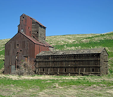 Just to the south of the road junction with Blue Mountain Station Road, about a quarter mile up Steen Road
toward Weston, there stood along the railroad an old grain elevator sided with weathered sun-darkened
wood and rusted sheet metal siding. I remember thinking back then that perhaps the old grain elevator was
related to Blue Mountain Station, but I just kind of forgot about it for over thirty five years until I recently ran
across an old 1880 railroad map and shown on that map at the end of a branch line was Blue Mountain
Station. The map was Colton's Township Map of Oregon & Washington Territory, issued
by the Oregon Railway and Navigation Company in 1880. The map showed Blue Mountain Station located
at the end of a branch line that ended by the township line between Township 4 North, Range 35 East and
Township 5 North, Range 35 East.
Just to the south of the road junction with Blue Mountain Station Road, about a quarter mile up Steen Road
toward Weston, there stood along the railroad an old grain elevator sided with weathered sun-darkened
wood and rusted sheet metal siding. I remember thinking back then that perhaps the old grain elevator was
related to Blue Mountain Station, but I just kind of forgot about it for over thirty five years until I recently ran
across an old 1880 railroad map and shown on that map at the end of a branch line was Blue Mountain
Station. The map was Colton's Township Map of Oregon & Washington Territory, issued
by the Oregon Railway and Navigation Company in 1880. The map showed Blue Mountain Station located
at the end of a branch line that ended by the township line between Township 4 North, Range 35 East and
Township 5 North, Range 35 East.

With my curiosity piqued again, over 35 years later, I decided to journey back through the lost passage of
time to see what I could discover through some research. I found on page 57 of the Standard Atlas of
Umatilla County Oregon, published by Geo. A. Ogle & Co. in 1914, a more detailed map having
section lines that showed Blue Mountain Station located in Section 35, Township 5 North, Range 35 East.
The 1914 county atlas also showed that the railroad had been extended from Blue Mountain Station,
immediately looping up through a couple horseshoe curves and constructed all the way to Pendleton. The
railroad through Section 35 was built along Dry Creek and along the early stage road noted on an 1867
township survey map as running from Boise City to Walla Walla.
A detailed 1:4800 scale Oregon-Washington Railroad & Navigation Company right-of-way and track
map, dated June 30, 1916 (revised December 31, 1927), shows that Blue Mountain Station by then was on
a 2804′ siding having an additional 547′ track beginning at
STA 20+332 and a 507′ track beginning at
STA 22+468 that were both on the left side of the
main siding. The map also shows at Blue Mountain Station; two warehouses, an elevator, two railroad
section houses, a railroad tool house and a railroad station sign. The right-of-way for the railroad tracks
and buildings at Blue Mountain Station (parcel No. 61) is listed on the map sheet as having been acquired,
from George H. Sargent, by the Walla Walla & Columbia River Railroad in July-October 1879. General
Land Office records reveal that George H. Sargent owned by 1872, in the Dry Creek drainage, 160 acres
comprising the E½SW¼ of Section 26 and the E½NW¼ of Section 35, Township
5 North, Range 35 East.
The Blue Mountain Branch Line originally ran from Whitman Junction located on the main line of the Walla
Walla & Columbia River Railroad, incorporated in 1868 by Dorsey Syng Baker and constructed in
Washington Territory between Wallula and Walla Walla from March 1872 to October 1875. At that time
Wallula was a major steamboat landing on the Columbia River and soon after the Walla Walla &
Columbia River Railroad was constructed Wallula became a major railroad junction. The 32-mile Walla
Walla & Columbia River Railroad main line was originally constructed as a 3-foot narrow gauge
railroad, with much of the first fifteen miles to Touchet constructed with wooden strap-iron rails, which were
replaced with iron rails soon after completion in 1875 of the narrow gauge main line to Walla Walla.
Raising livestock had been the main local pioneer livelihood, but Marcus Whitman had his first small grist
mill at the mission at Waiilatpu as early as 1839. The next oldest grist mill was built in 1859 by Almos H.
Reynolds in partnership with John A. Simms and also Capt. Frederick T. Dent (brother-in-law of Ulysses
S. Grant) who at that time was on frontier duty at U.S. Army Fort Walla Walla. This early grist mill was
located along a stream tributary to Yellowhawk Creek, just west of the Ransom Clark donation land claim
and about a mile south of the U.S. Military Reserve of Fort Walla Walla. This grist mill was known as
Simms' Grist Mill by the early 1860s and was located on land later owned by William G. Whitney
and his son Charles L. Whitney. Another grist mill also began operation, at Milton, in about 1873. Before
the Walla Walla & Columbia River Railroad main line was constructed, farmers had to haul grain by
wagon to one of the early grist mills around Walla Walla or Milton, or haul it to either Umatilla Landing or
Wallula Landing on the Columbia River for river transport to other mills. When the railroad main line was
completed to Walla Walla in 1875, that year, 9155 tons of wheat was transported on the railroad to
Wallula. Like in the Palouse region the highly productive soils in the part of the Columbia Plateau along
the western foot of the Blue Mountains soon became renowned for producing high yields of wheat, which
led to the construction of the Blue Mountain Branch Line.
In early 1879 D.S. Baker sold most of his interest in the Walla Walla & Columbia River Railroad to
the chief owners of the Oregon Steam Navigation Company. They made the Walla Walla & Columbia
River Railroad a subsidiary of that company and continued to extend the narrow gauge railroad by
constructing that same year the Blue Mountain Branch Line, before operation of the Walla Walla &
Columbia River Railroad came under the management of the Oregon Railway & Navigation Company
early the following year.
The narrow gauge Blue Mountain Branch Line was constructed in 1879 from Whitman Junction in
Washington Territory for fourteen miles to Blue Mountain Station, in the State of Oregon, through what
eventually became part of an important wheat belt due in large part to the arrival of the railroad. Blue
Mountain Station was established as a temporary terminus of the branch line at a point where the
topography made the grade construction more difficult. For about seven years Blue Mountain Station, in the
Dry Creek drainage, was the terminus of the Blue Mountain Branch Line and many loads of wheat were
brought there by wagon from around the area for transfer as train cargo. The Steen and Winn families, after
whom the two county roads in the Dry Creek drainage were named, were among the early farmers who
raised wheat around that area when the railroad first arrived.
By the time the Blue Mountain Branch Line was constructed, to Blue Mountain Station, six narrow gauge
steam locomotives, built by Porter, Bell & Company, worked the Walla Walla & Columbia River
Railroad. The locomotives were: the Walla Walla, built in 1872 (c/n 114); the Wallula, built in
1872 (c/n 124); the Columbia, built in 1876 (c/n 246); the Blue Mountain, built in 1878
(c/n 283); the Mountain Queen, built in 1878 (c/n 289); and the J.W. Ladd, built in 1878
(c/n 292). Under the management of the Oregon Railway & Navigation Company these six
locomotives were numbered respectively as No. 1 through No. 6. All but two of these locomotives were
moved elsewhere, in 1881, when the main line to Walla Walla was changed over to standard gauge track.
The two locomotives that remained were the Columbia (No. 3) and the Blue Mountain (No. 4)
and they continued to work the Blue Mountain Branch Line until it was converted, in 1883, to standard
gauge track also. The remains of the WW&CR Blue Mountain, 0-6-0, steam locomotive still
exist and are preserved at the Washington State Railroads Historical Society Museum in Pasco,
Washington. The WW&CR Blue Mountain, which was built at Pittsburgh, Pennsylvania, in 1878,
by Porter, Bell & Company, is the oldest existing steam locomotive in the State of Washington.
It wasn't until early 1887 that the Blue Mountain Branch Line was finally connected to Centerville
(renamed Athena in 1889) and it became the Walla Walla and Pendleton Branch Line. The Annual Report
of the Board of Directors of the Oregon Railway and Navigation Company reported in 1887 that during the
year “[…] the gap between Blue Mountain and Centerville, on the Walla Walla and Pendleton
branch, a distance of 10 miles, was built.”
Even though Blue Mountain Station and Centerville were only ten miles apart it took from late 1879 to early
1887 to make the connection. The construction delay was due to emphasis on other railroad construction,
a decision to change the railroad from narrow gauge to standard gauge track, a relocation of the starting
point of the Blue Mountain Branch Line from Whitman Junction to Walla Walla and involved construction of
the steep grade looping up through a couple horseshoe curves beyond Blue Mountain Station. About five
years after this steep grade was constructed Crofutt's Overland Guide, by George A. Crofutt,
described in 1892 the railroad looping up through these two horseshoe curves beyond Blue Mountain
Station as “[…] showing parallel tracks one far above the other. Between these tracks, at the
lower end of the great curve, is situated a platform for shipping wheat called Blue Mountain, six miles from
Weston by rail […].” The railroad had already been constructed from Pendleton to Centerville
in 1884, as the Centerville Branch Line, so in 1887 when the gap was finally connected between Blue
Mountain Station and Centerville trains could then run on standard gauge track between Walla Walla and
Pendleton and beyond. The Oregon-Washington Railroad & Navigation Company right-of-way and
track map, dated June 30, 1916 (revised December 31, 1927), shows the lower horseshoe curve looping
around 199° 15′ with a degree of curvature of 10° per 100 feet and the upper horseshoe
curve looping around 176° 24′ with a degree of curvature of 8° per 100 feet.
During the 1880s the public timetables of the Oregon Railway & Navigation Company listed Blue
Mountain Station as having a telegraph station and as being a scheduled passenger train stop, even for
a while after the branch line was connected to Pendleton and it became the Walla Walla & Pendleton
Branch Line with scheduled train stops at nearby Weston. In 1896 the Oregon Railway & Navigation
Company was reorganized as the Oregon Railroad & Navigation Company, which was then later
consolidated in 1910 along with about a dozen other railroads including the former Walla Walla &
Columbia River Railroad into the Oregon-Washington Railroad & Navigation Company. Sometime
probably around that time period the old grain elevator at Blue Mountain Station was built, apparently
replacing an earlier loading platform for shipping wheat and the old grain elevator still stands there as a
nostalgic reminder of times gone by.
References:
Annual Report of the Board of Directors of the Oregon Railway and Navigation Company; for
the year ended June 30, 1887. New York: Searing & Hyde, Stationers, 1887. Page 7.
Crofutt, George A. Crofutt's Overland Guide: Consisting of over six thousand miles of main
tours, and three thousand miles of side tours, also six thousand miles by stage and water.
Descriptive—Illustrated. Saint Louis: Charles E. Ware Publisher, 1892. Page 223.
Cullum, George W. Biographical Register of the Officers and Graduates of the U.S. Military
Academy, from 1802 to 1867. Rev. ed., with a supplement continuing the register of graduates to
January 1, 1879. Vol. 2 (1841–1867). New York: James Miller, Publisher, 1879. Page 95.
Evans, Elwood. History of the Pacific Northwest: Oregon and Washington; embracing an account of
the original discoveries on the Pacific Coast of North America…. Vol. 2.
Portland: North Pacific History Company, 1889. Page 535.
Executive Documents of the House of Representatives: for the second session of the
fifty-first Congress, 1890–'91. Report on the internal commerce of the United States for
the year 1890; Part II of Commerce and Navigation. Washington D.C.: Government Printing Office,
1891. Pages 981–982.
G.W. & C.B. Colton & Company. Colton's Township map of Oregon & Washington
Territory.
New York: issued by Oregon Railway and Navigation Company, 1880.
Lyman, William Denison. Lyman's History of old Walla Walla County: embracing Walla Walla,
Columbia, Garfield and Asotin Counties. Chicago: S.J. Clarke Publishing Company, 1918.
Pages 165–170, 186–188.
Oregon-Washington Railroad & Navigation Company. Right-of-Way and Track Map: Branch
Line—Pendleton to Tucannon, Sheet V-ORE.12 07, Issued June 30, 1916 (Revised December
31, 1927). Scale: 1 inch = 400 feet (1:4800). Portland: [OWRR&N Co.] Office of Chief
Engineer, 1927.
Poor, Henry Varnum. Poor's Manual of the Railroads of the United States for 1880.
New York: H.V. & H.W. Poor, 1880. Page 998.
Poor, Henry Varnum. Poor's Manual of Railroads for 1887. New York: H.V. & H.W.
Poor, 1887. Page 867.
Standard Atlas of Umatilla County, Oregon: including a plat book of the villages, cities
and townships of the county…. Chicago: Geo. A. Ogle & Co., Publishers &
Engravers, 1914.
The Quarterly of the Oregon Historical Society. Vol. XVI, No. 4 (December, 1915). Early
Farming in Umatilla County, by C. A. Barrett. Portland: Oregon Historical Society, 1915.
Pages 343–349.
Travelers' Official Guide of the Railway and Steam Navigation Lines of the United States
and Canada. New York: National Railway Publication Company, 1881–'89.
<< BACK
 Andrew Craig Magnuson
Forks, Washington
May 20, 2013

Revised July 15, 2015
Copyright © by Andrew Craig Magnuson
|